

Tornadoes
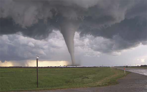 Tornadoes are violently rotating columns of air extending from a thunderstorm to the ground (NOAA Web site, online data). Though most often associated with the central United States, tornadoes have been documented in all 50 states. Tornadoes can also occur at any time of the year, although the peak season for tornadoes in the Kansas City area is the spring and summer. In addition, tornadoes can occur at any time of the day, though they are most likely to occur between 3 and 9 p.m.
The average period of a tornado’s ground contact is 30 minutes, covering an average distance of 15 miles a review of Missouri tornadoes occurring between 1950 and 1996, the National Weather Service calculated a mean path length of 2.27 miles and a mean path area of 0.14 square miles. The damage associated with tornadoes is primarily caused by wind speed; in general, the greater the wind speed, the greater the potential for damage. The violently rotating winds of a tornado can break branches and uproot trees, tear roofs off houses, lift vehicles off the ground, remove walls from houses and topple well-constructed homes and other structures. In addition, a large amount of debris can be generated by a tornado’s destructive winds and objects can become “missiles,” indirectly damaging structures and injuring or killing people through the force of their impact.
A total of 18 tornado events since the last plan update occurred on eight specific dates: May 16, 2015 * July 1, 2015 * September 18, 2015 * March 6, 2017 * June 26, 2018 * July 6, 2017 * May 2, 2018 * October 9, 2018
More information on Tornadoes in the region»
Floods
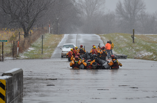 With the exception of fires, floods are the most common and widespread of all-natural disasters. Most communities have experienced some type of flooding. Flooding occurs when normally dry areas of land are partially or completely inundated by water.
Floods are caused by a number of conditions, including widespread and/or intense rainfall; runoff from deep snow cover (usually a combination of heavy rain, rapid warming and rapidly melting snow); over-saturated soil (the ground cannot absorb any more water); frozen soil that cannot absorb as much water as soil that is not frozen; high river, stream or reservoir levels preceding heavy or extended rains; ice jams in rivers and streams (these can flood upstream locations and, when they break, downstream locations); and urbanization (large amounts of pavement and buildings inhibit water absorption by the soil and cause rainwater to flow into sewers and drainage ditches and overflow them).
Several types of flooding may adversely affect the Kansas City area: riverine floods, flash floods and sheet floods. Riverine flooding occurs when rivers, streams, lakes, reservoirs or drainage systems overflow due to excessive rainfall, rapid snowmelt or ice jams.
More information on Floods in the region»
Severe Winter Weather
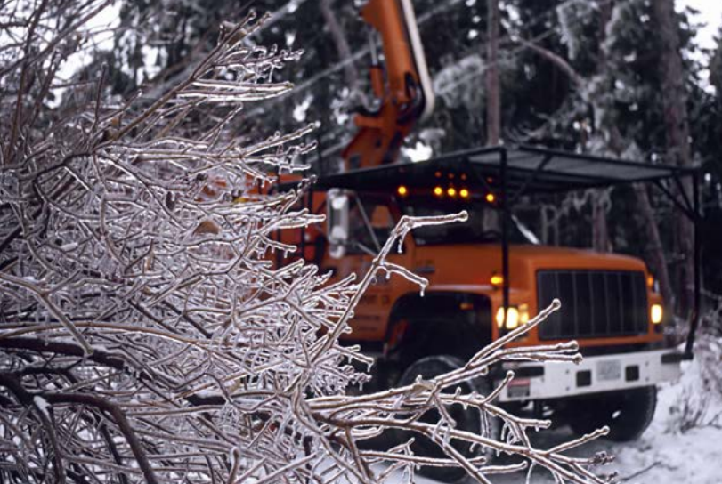 Severe winter weather, including snow storms, ice storms and extreme cold, may affect any part of Cass, Clay, Jackson, Platte and Ray counties any given winter season. Although the annual snowfall amount in the Kansas City area is moderate — generally around 20 inches — the area may be affected by a full range of snowy conditions, including blizzards, blowing snow, snow squalls, snow showers and snow flurries. These snowy conditions are defined as follows:
Blizzard – Winds of 35 mph or more with snow and blowing snow reducing visibility to less than one-quarter mile for at least three hours.
Snow Squalls – Brief intense snow showers accompanied by strong, gusting winds; accumulation may be significant.
Blowing Snow – Wind-driven snow that reduces visibility; blowing snow may be falling snow and/or snow on the ground picked up by the wind.
Snow Showers – Snow falling at varying intensities for brief periods of time. Some accumulation is possible.
Drifting Snow – Uneven distribution of snowfall caused by strong surface winds. Drifting snow does not reduce visibility.
Snow Flurries – Light snow falling for short durations with little or no accumulation.
Ice storms may also affect the Kansas City area during the winter months. In ice storms, damaging accumulations of ice occur during a period of freezing rain. Freezing rain or freezing drizzle occurs when rain or drizzle freezes on surfaces, such as roads, bridges, cars and trees, forming a coating or glaze of ice. In freezing rain or freezing drizzle situations, air temperatures are warm enough for rain to form, but surface temperatures are below 32 degrees (i.e., below freezing), causing rain or drizzle to freeze on contact with surfaces. Sleet is raindrops that freeze and form ice pellets before reaching the ground. Like hail, sleet may “bounce” when it hits the ground or other surface instead of sticking and forming a coating. Sleet, however, may accumulate like snow. Sleet is the accumulation of half an inch or more of sleet.
More information on Severe Winter Weather in the region»
Extreme Heat/Dought
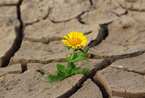 A drought’s severity is dependent on a variety of factors, including its duration, the degree of moisture deficiency and the size of the affected area. Drought can be exacerbated by other climatic conditions, including high temperatures, high winds and low humidity.
There are five categories of drought, each one relating the occurrence of drought to water shortfall in some component of the hydrological cycle. These categories are operational definitions and help to describe the onset, severity and end of droughts. Each category affects patterns of water and land use and refers to a repetitive climatic condition. The categories include:
Meteorological Drought – is a measure of precipitation’s departure from normal over a period of time. This definition of drought is region-specific, i.e., a drought in one area may not be considered a drought in another area. According to the National Drought Mitigation Center (NDMC), meteorological measurements usually provide the first indication of drought.
Agricultural Drought – occurs when there is not enough moisture in the soil to meet the needs of a crop at a particular time. According to the NDMC, agriculture is usually the first economic area to be affected by drought.
Hydrological Drought – occurs when surface and subsurface water supplies are below normal. Hydrological drought is determined by streamflow and by lake, reservoir and groundwater levels. Hydrological indicators do not provide early indications of drought, since there is a delay between periods with little or no precipitation and low levels of surface and groundwater.
Hydrological Drought and Land Use – refers to a meteorological drought in one area that has hydrological impact in another area. For example, a drought in the Rocky Mountains may have a significant impact in Missouri, since the Missouri River and its tributaries are partly dependent upon precipitation upstream and snowmelt.
Socioeconomic Drought – occurs when a physical water shortage begins to affect people.
More information on Extreme Heat/Drought in the region»
Severe Thunderstorms (Wind, Hail, Lightning)
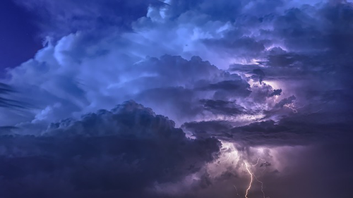 Many hazardous weather events are associated with thunderstorms. Under the right conditions, rainfall from thunderstorms can cause flash flooding, which kills more people each year than hurricanes, tornadoes or lightning. Lightning is responsible for many fires around the world each year and is also capable of causing fatalities. Hail up to the size of softballs damages cars and windows and can kill livestock caught out in the open. Strong straight-line winds associated with thunderstorms may knock down trees, power lines and mobile homes. Tornadoes (with winds up to about 300 mph) can destroy all but the strongest man-made structures.
Other dangers associated with thunderstorms include tornadoes, strong winds, hail and flash flooding. The damaging straight-line winds of thunderstorms can exceed 100 mph. Some thunderstorms produce downbursts — a sudden outrush of damaging wind. Microbursts are smaller scale events that have a damage area less than 2.5 miles wide. Microbursts are larger events where the damage area is wider than 2.5 miles. Downbursts can produce strong wind shears (rapid changes in the speed and/or direction of wind over a short distance) near the surface.
Thunderstorms associated with tornado development also contribute to the number one killer — flash floods. According to the National Weather Service, Preliminary US Flood Fatality Statistics, floods and flash flooding are responsible for more fatalities — 182 fatalities in 2017 and 84 in 2018 — than any other thunderstorm-associated hazard. As of June 2019, there have been 67 flood fatalities in the United States.vi Dry thunderstorms, which produce rain that does not reach the ground, are most prevalent in the western United States. Falling raindrops evaporate, but lightning can still reach the ground and can start wildfires. Large hail can reach the size of grapefruit. Hail causes several hundred millions of dollars in damage annually to property and crops across the nation.
Thunderstorms are most likely to occur in the spring and summer months and during the afternoon and evening hours, but they can occur year-round and at all hours. Thunderstorms frequently form in the late afternoon and at night in the Plains states. The greatest severe weather threat extends from Texas to southern Minnesota, but no place in the U.S. is completely safe from the threat of severe weather. Of the 469 thunderstorm, hail, and lightning events that have occurred since January 1, 2014, six are damaging wind events, one is a damaging hail event and two are damaging lightning events. Winds caused roughly $106,000 in damage, the hail event accounted for $10,000 in damages, and the two lightning events caused $51,000 in damage according to the NOAA NCDC web site. On July 5, 2018 one person was killed due to a lightning strike.
More information on Severe Thunderstorms in the region»
Grants Information
- FEMA Grant announcement for disaster declaration State of Missouri Hazard Mitigation funding, August 1, 2019
- Flood Mitigation Assistance (FMA) Notice of Interest
- PDM Notice of Interest
- Local Match Guidance, Sept. 26, 2019